By Theo Witsell, Chief Ecologist and Co-founder of SGI
During the last week of May, I joined SGI Executive Director Dwayne Estes, Research Associate Zach Irick, and SGI volunteer/Hendrix College student Ben Benton in the Big South Fork National River and Recreation Area for three days exploring riverscour grasslands along the rugged and beautiful Clear Fork River. This marked the beginning of our project, funded by the National Park Service, to document the flora and plant communities of open habitats in the riparian corridor as well as map populations of rare and invasive species.
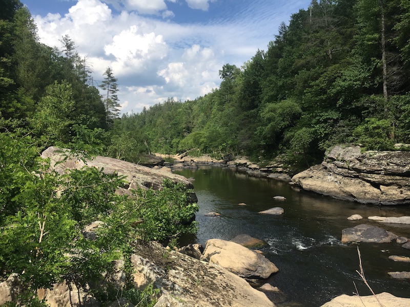
“Riverscour” is a wonderfully descriptive name for fascinating shrubby grasslands found at the bottoms of narrow, hemmed-in river gorges along high gradient mountain rivers (FIG 1). They are maintained by violent floods that blast down the rivers from time to time, carrying cobbles and boulders that scour away trees and tip the balance in favor of colony-forming shrubs and grassland plants. This results in a complex mosaic of open and semi-open habitats that sort out along gradients of slope, soil depth, hydrology/distance from the water, and substrate size (ranging from stable bedrock and huge boulders on down to more dynamic cobble, gravel, sand, and silt). Some zones support prairie-like grasslands, while others support diverse shrublands, desert-like sand barrens, bedrock glades, savannas, and open woodlands. There are also occasional embedded pocket wetlands including small groundwater seeps and backwater marshes. Each of these natural communities has its own distinctive flora and the system as a whole is home to some exceptionally rare plant species found only in riverscour.
FIG 1a-f. Examples of various riverscour habitats along the Clear Fork River, within the Big South Fork National River and Recreation Area, Scott County, Tennessee. Photos by Theo Witsell.
Probably highest plant diversity in the entire river gorge
The plant diversity in this narrow corridor of habitats is probably the highest in the entire river gorge, with a diverse mix of aquatic plants, riparian and wetland species, dry glade and grassland species, and species from the surrounding mesic slope forests. We define the limits of the riverscour as the point at which the flood-scoured woodland communities (fairly open and with some grassland plants) gives way to the flood-scoured forest community (closed, shaded, and without grassland plants, but still with evidence of flooding).
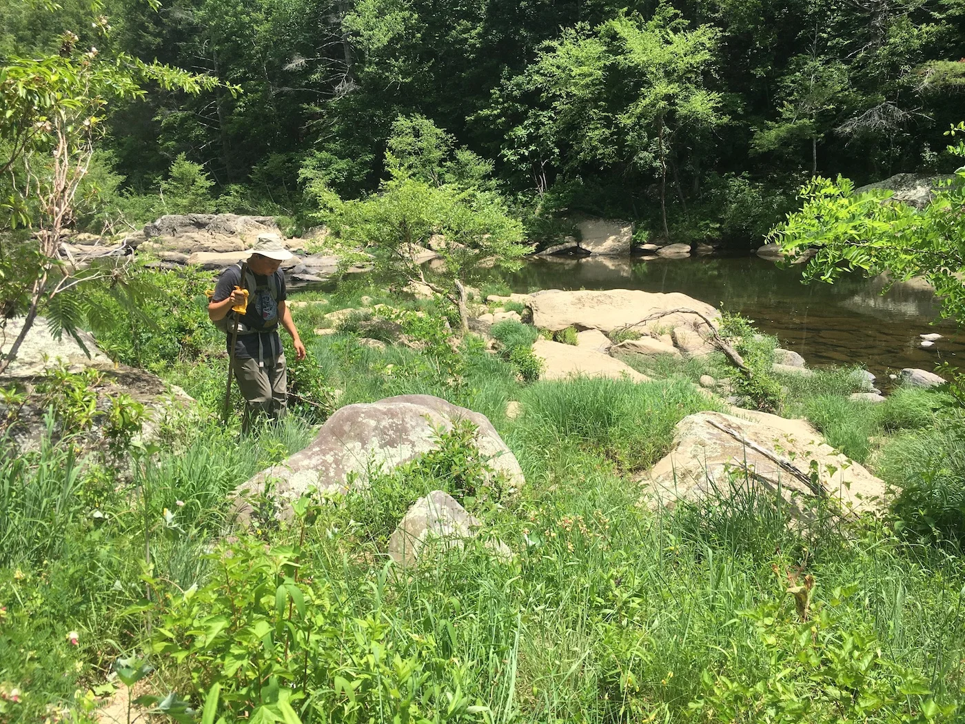
Riverscour surveys are notoriously difficult, requiring slow, careful foot travel along the narrow bottoms of steep-sided river gorges (FIG 2 below left). This involves negotiating a seemingly endless procession of large boulders (ranging from table-sized to car-sized to some that are even house-sized) that line the riverbanks, wading the river on slippery, tilted rocks, and occasionally either scrambling up adjacent slopes to get around long deep pools or just swimming across them (FIG 3 below right). Scour zones often alternate sides of the river, so there is a lot of stream crossing. And because these grasslands are often shrubby, they take time to adequately survey for rare herbaceous (non-woody) plants.
FIG 2 .(left) Hard Travelin’: SGI Research Associate Zach Irick and volunteer Ben Benton survey riverscour along the Clear Fork. Riverscour surveys require slow, careful walking down boulder-strewn river gorges, stopping to explore every sand, gravel, cobble, or boulder bar. Photo by Theo Witsell.
FIG 3. (right) Not your average grassland survey: At narrow pinch points in the river gorge, long, deep pools and huge boulders span from bluff to bluff, leaving two options for travel: hike upslope, over, and around, or swim through the pools. SGI Research Associate Zach Irick takes the short, wet route. Photo by Theo Witsell.
Cottonmouths? No. Rattlesnakes? Yes! Plus globally rare species . . .
Fortunately, there are no Cottonmouths (Agkistrodon piscivorus) in the Big South Fork watershed, but rocky portions of the riverscour are prime habitat for Timber Rattlesnakes (Crotalus horridus), so you still have to keep your eyes and ears out and pay careful attention to where you step. We encountered three in one day and saw the freshly shed skin of a fourth. At one point we were walking single file through a particularly rocky section and suddenly heard that unmistakable and eerie rattle, seemingly coming from all around us but from nowhere in particular at the same time. We all jumped up onto a high ledge of bare rock to look for the source but couldn’t find it. Some tapping around with a walking stick induced it to rattle again (See FIG 4 video below) and we discovered it was under a large rock inches from where I had stepped a minute before!
FIG 4 (VIDEO). We find the location of a hidden Timber Rattlesnake (Crotalus horridus) by getting it to rattle a second time after I stepped inches from it a minute earlier and got a very clear and familiar warning. Video by Ben Benton.
But what we were really looking for (and found!) were several globally rare plants including Cumberland Rosemary (Conradina verticillata) and Virginia Spiraea (Spiraea virginiana), both of which are listed as Threatened under the federal Endangered Species Act, and Large-flowered Barbara’s Buttons (Marshallia grandiflora), which is listed as Endangered by the State of Tennessee—all shown below in FIG 5.
FIG 5. Rare Finds: Top to bottom and left to right: (a) Cumberland Rosemary (Conradina verticillata) is a fragrant, low, creeping shrub listed as Threatened by both the U.S. Fish and Wildlife Service and the State of Tennessee. It is found in sandy riverscour in the Cumberland Plateau and Eastern Highland Rim in Tennessee and Kentucky, and nowhere else. (b, c) Virginia Spiraea (Spiraea virginiana) is another rare colony-forming shrub endemic to riverscour. It is listed as Threatened by the U.S. Fish and Wildlife Service and Endangered by the State of Tennessee. Photos by Theo Witsell.
Rare Finds: Top to bottom and left to right: 3 photos of Large-flowered Barbara’s Buttons (Marshallia grandiflora), a globally rare wildflower endemic to riverscour grasslands in a few areas of the Appalachians. It is listed as Endangered by the State of Tennessee. Photos by Ben Benton (flower) and Theo Witsell (leaves).
We also found previously undocumented sites for Bog Oat-grass (Danthonia epilis), Northern White-cedar (Thuja occidentalis, FIG 6), and Silky Dogwood (Cornus obliqua) which are all tracked as species of state conservation concern by the Tennessee Natural Heritage Program.
FIG 6. Rare Finds: SGI volunteer Ben Benton with a specimen of Northern White-cedar (Thuja occidentalis). This species is at the southern edge of its range on the Cumberland Plateau and is listed as a species of state conservation concern by the Tennessee Natural Heritage Program. Photos by Theo Witsell.
Not all good finds . . .
It wasn’t all good finds though. As we cataloged each species we encountered, we documented a number of non-native invasives including Silktree or Mimosa (Albizia julibrissin), Japanese Spiraea (Spiraea japonica), Tall Fescue (Schedonorus arundinaceus), Chinese Privet (Ligustrum sinense), and the ever-present riverscour invader Sericea Lespedeza (Lespedeza cuneata).
This was just one of many trips we will make to the Clear Fork on this project and we anticipate making many more interesting discoveries. As we conduct the surveys we are taking photos of many species and posting them on iNaturalist. Anyone interested in what we are finding can see them in the iNaturalist project Riverscour Barrens of the Clear Fork River, Tennessee.
FIG 1. Banner photo: A riverscour habitat along the Clear Fork River, within the Big South Fork National River and Recreation Area, Scott County, Tennessee. Photo by Theo Witsell.


